The SW foothills of Mt.Hood are primed with good roads, ton’s of options, sick views and lower traffic.
Three Milage Options – https://ridewithgps.com/routes/48073789
Several services and stop points on the map.
35,55 and 70mile options.
This area is not flat!
Marmot, Shipley, Kitzmiller, Pugh and Wildcat are some of the names that pop up when you mention superb roads in the west foothills of Mt Hood. This past weekend I was working to put together a 3 option ride in the beautiful area to incorporate these. The idea being a well paced 35, 55 or 70 mile road ride, with low traffic roads, excellent and varied terrain with great views.

I’m going for an an all in one style route where you can choose your journey, as you ride.. Options of 35, 55 or 70miles. So if you’re not feeling 70miles mid way through, no problem just do the 55. Wanting more elevation?, no problem the 70m there for you. Just getting into things, 35miles and back to base, no prob;bob.
The difficulty here is making the experience great on all distances. Keeping high quality in terms of road quality, elevation pacing, distance between services and also providing scenery / points of interest on each distance. All in, thats a tricky thing to do.

First the pacing, thats really important. Climbs are part of a great ride but also and critically is recovery, unless you are 25yrs old or a Tadej pogačar you cannot be punching back to back mountain climbs and expect to feel good. Mandatory is downtime to refresh and enjoy what you worked for, either the view or the descent.
Heres the pacing on my route:
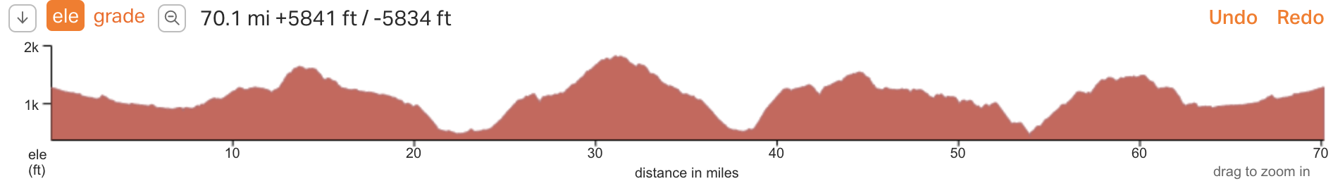
The 70 mile route is the above with 4 major well spaced climbs. When I say major, I mean 1000ft plus climbs.
The 55 route eliminates the second elevation bump
The 35 route eliminates bump 2 and bump 3
The final climb tops out on Marmot Rd and descends spectacular and is retained in all routes, back to the finish point.

Im still tweaking the routes to make them as optimum as I can get them. But at the moment they are all well balanced and hit close to the golden ratio of 100ft elevation gain per mile.
35miles – 3000ft
55 miles – 4700ft
70miles – 6800ft


more to come, stay tuned.
Latest Posts
- TPU vs. Butyl Tubes: What You Need to Know
- Wahoo Trackr Radar and flashing unit competes with established Garmin Varia for top radar spot
- Crosspoint Gear and Showerspass waterproof knit gloves suck the vapid murk right out of the clouds
- My 2025 Top Indoor Training Accessories for a more enjoyable ride and Better Performance
- Product Review : Maximize Your Cycling with 4iiii (Foureye) Power Meters – Precision 3+ Review
Discover more from Buckyrides
Subscribe to get the latest posts sent to your email.

Leave a Reply